The Hangers Way is a 21-mile long-distance footpath through Hampshire, running north to south and stretching from Alton to Queen Elizabeth Country Park.
The path passes along a series of steep-sided wooded chalk hills known as The Hangers, so offers plenty of undulations – some quite steep – for the walker.
As much of the walk is through woodland, we chose to make our journey at bluebell time when the route would be most beautiful – and we decided to split our venture across two days.
So it was that six of Petersfield Ramblers’ keenest walkers gathered at Alton Station to start part one of their hike.


Fortunately, we found the route well signposted.
In places there were bold signs that couldn’t be missed but largely the signposting was discrete, comprising small discs nailed to posts, displaying the Hangers Way logo – a slope with a tree on it in green and white.
We quickly cleared the outskirts of Alton, crossing the A31 to find ourselves in fields, overlooking an extensive solar farm.
A gentle ascent took us through arable land and green pastures on the side of Neatham Down, with wide views in all directions, until we dropped gradually into East Worldham.
Regaining higher ground, we skirted King John’s Hill, passing through sheep fields with more panoramic views over a cluster of small lakes to the north-east.
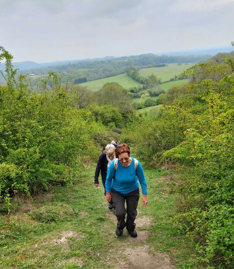
For the next mile or so the route took us south through woodlands – bursting into life.
Hugging the side of the Hangers, our path was consistently edged with pungent wild garlic.
In fact, this combination of woodland and wild garlic on the slopes of the rolling chalk hills became a recurring theme of our walk right down to Queen Elizabeth Country Park.
Occasionally we encountered patches of bluebells – generating much debate about whether these were delicate English bluebells or the more invasive Spanish variety.
In drier areas we found lime-green euphorbia and then – to our delight – a clump of early purple orchids.
After five miles, Selborne church came into sight – the churchyard a hive of industry with grass cutting and tree trimming.
We dropped rapidly into the village, stopping at the café by Gilbert White’s House for a break with coffee, and sublime ice-cream, or very inexpensive craft beer, depending on your fancy
Refreshed, we set off for Noar Hill – but not before stroking a beautiful little pony we nicknamed Boris, on account of his floppy blond mane.
Noar Hill is a 20-hectare (49 acres) nature reserve managed by the Hampshire and Isle of Wight Wildlife Trust.
It forms one of the westerly outposts of the chalk South Downs, and rises to about 210m above sea level.
The western and northern flanks slope fairly gently, but the eastern and southern flanks are quite steep in places.
And thankfully the hill was the driest any of us could recall in over six months.
This was such a blessing as our route required us to circumnavigate the mound almost completely, hugging the 180m contour.
After a steep descent we began our trek to Hawkley, via Hawkley Hanger, along wild garlic edged woodland paths.
There – after 12 miles of walking and climbing 1,175ft in total over six hours – we called it a day, leaving the rest of the Hangers Way for the following week.
Luckily the weather was as perfect for the second part of our venture as it had been for the first: dry, sunny at times but not hot.
Leaving Hawley we soon encountered the steepest climb of the whole trail: the ascent to the top of Ashford Hangers.
We stopped at points to admire the views behind us – and to get back our breath – and cheered when we reached the summit.
Now on very familiar territory, we descended the Hangers via a safer, zig-zag path, reaching the road by ‘Petersfield’s waterfall’, an old mill race that feeds a stream on the other side of Mill Lane.
Our route then took us down into Steep, passing the village church, All Saints Church and Bedales School, before crossing the A3 and dropping into Petersfield.
We all commented how strange it felt to traverse our home town on a walk, continuing south via The Causeway to green fields leading to Buriton.
It was here that we found our best bluebells, and also newly-emergent hawthorn blossom.
Our final mile took us through Queen Elizabeth Country Park, over a final chalk ridge, and to our journey’s end, the country park visitor centre.
And here we celebrated our achievement with coffee and very tasty cake.
Comments
This article has no comments yet. Be the first to leave a comment.